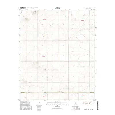
2017 Map of Camaleon Draw West
USGS Topo · Published 2017About this map
Camaleon Hill and the surrounding high desert terrain define this landscape at the border of Lincoln and Torrance counties. The area is characterized by sparse development, with a geography shaped by drainage features such as Cola del Gallo Arroyo and prominent elevations like Trinchera Mesa in the northwestern corner. The Public Land Survey System grid heavily structures the territory, shown here divided into several townships including t1n r14e and t2n r15e. Roadways are minimal, consisting primarily of county routes like Co Rd A030 and Co Rd C020, which cross the arid landscape. This map provides a detailed view of the natural topography and administrative boundaries before modern expansion, serving as a clean record of the land's physical contours and historical land divisions.
Find a feature on this map
12 named features on this map. Tap any name to fly to it.
Don’t see what you’re looking for? This feature index may not catch every label — zoom into the map to look around manually.
Map Details
Editions of this 2017 Camaleon Draw West Map
This is the sole edition of this map. No revisions or reprints were ever made.
Other maps of this area

1954 · Fort Sumner
USGS Topo · 1:250,000

1958 · Fort Sumner
USGS Topo · 1:250,000

1980 · Corona
USGS Topo · 1:100,000

1981 · Gallo Spring Canyon
USGS Topo · 1:24,000

1981 · Camaleon Draw West
USGS Topo · 1:24,000
1981 · Duran
USGS Topo · 1:24,000

1981 · Camaleon Draw East
USGS Topo · 1:24,000
1981 · Duran NE
USGS Topo · 1:24,000
1981 · Cedarvale NE
USGS Topo · 1:24,000

1981 · Corona South
USGS Topo · 1:24,000