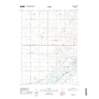
2018 Map of Camanche
USGS Topo · Published 2018About this map
The Mississippi River serves as the primary geographic anchor for this region, delineating the border between Iowa and Illinois while creating a complex network of backwaters and islands including Camanche Island, Swan Island, and Meredosia Island. The settlement of Camanche sits along the riverbank, its grid transitioning into the more industrial and agricultural outskirts of Clinton to the north. Inland, the landscape is defined by the drainage basins of Rock Cr and Sodus Cr, which cut through the terrain toward the river. Genealogists will find significant value in the distribution of family and community burial grounds across this agricultural landscape, including Elvira Cem, Pleasant Hill Cem, and Shaffton Cem. The presence of the Clinton Municipal Airport and major corridors like Lincoln Way and Anamosa RD reflect the area's role as a transportation hub, connecting smaller townships like Low Moor and Shafton to the larger river economy.
Find a feature on this map
74 named features on this map. Tap any name to fly to it.
Don’t see what you’re looking for? This feature index may not catch every label — zoom into the map to look around manually.
Map Details
Editions of this 2018 Camanche Map
This is the sole edition of this map. No revisions or reprints were ever made.
Other maps of this area

1891 · Clinton
USGS Topo · 1:62,500

1892 · Goose Lake
USGS Topo · 1:62,500

1892 · Leclaire
USGS Topo · 1:62,500

1893 · Leclaire
USGS Topo · 1:62,500

1894 · Goose Lake
USGS Topo · 1:62,500

1894 · Clinton
USGS Topo · 1:62,500

1899 · Clinton
USGS Topo · 1:125,000

1952 · Erie
USGS Topo · 1:62,500

1952 · Clinton
USGS Topo · 1:62,500
1952 · Cordova
USGS Topo · 1:24,000