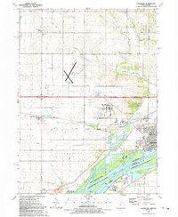
1991 Map of Camanche
USGS Topo · Published 1992About this map
Camanche and its surrounding townships in Clinton County reveal a landscape shaped by the Upper Mississippi River and a dense network of country roads. Small settlements like Low Moor and Shaffton are anchored by the Chicago and North Western rail line, which cuts across the fertile plains of Camanche Twp and Eden. Notable landmarks for local historians include the Elvira Zion Ch and the Pleasant Hill Cem, alongside various family-named landmarks like Devils Hollow and Hansen. The eastern edge of the map is dominated by the river environment, featuring the Schricker Slough and the expansive Upper Mississippi River National Wild Life and Fish Refuge, which buffers the industrial cooling towers and gaging stations near the riverbank. This documentation of the late 20th-century landscape captures the transition between rural farmland and the developing municipal infrastructure of the Clinton Municipal Airport.
Find a feature on this map
51 named features on this map. Tap any name to fly to it.
Don’t see what you’re looking for? This feature index may not catch every label — zoom into the map to look around manually.
Map Details
Editions of this 1991 Camanche Map
This is the sole edition of this map. No revisions or reprints were ever made.
Other maps of this area

1891 · Clinton
USGS Topo · 1:62,500

1892 · Goose Lake
USGS Topo · 1:62,500

1892 · Leclaire
USGS Topo · 1:62,500

1893 · Leclaire
USGS Topo · 1:62,500

1894 · Goose Lake
USGS Topo · 1:62,500

1894 · Clinton
USGS Topo · 1:62,500

1899 · Clinton
USGS Topo · 1:125,000

1952 · Erie
USGS Topo · 1:62,500

1952 · Clinton
USGS Topo · 1:62,500
1952 · Cordova
USGS Topo · 1:24,000