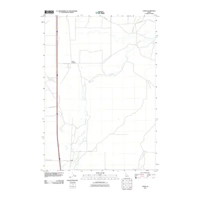
2010 Map of Camas
USGS Topo · Published 2010About this map
Camas stands as the primary settlement in this high-desert landscape, situated where the seasonal waters of Beaver Creek and Camas Creek converge. The area's transport history is defined by the parallel paths of modern infrastructure and legacy routes, most notably Old Hwy 91, which runs north-south through the western portion of the quadrangle. This corridor represents a critical link in the region's historical connectivity, bypassed by the modern interstate but remaining vital for local access.
Find a feature on this map
14 named features on this map. Tap any name to fly to it.
Don’t see what you’re looking for? This feature index may not catch every label — zoom into the map to look around manually.
Map Details
Editions of this 2010 Camas Map
This is the sole edition of this map. No revisions or reprints were ever made.
Other maps of this area

1955 · Dubois
USGS Topo · 1:250,000

1955 · Idaho Falls
USGS Topo · 1:250,000

1958 · Dubois
USGS Topo · 1:250,000

1958 · Idaho Falls
USGS Topo · 1:250,000

1964 · Dubois NW
USGS Topo · 1:24,000

1964 · Lone Butte
USGS Topo · 1:24,000

1964 · Dubois NE
USGS Topo · 1:24,000
1964 · Hamer
USGS Topo · 1:24,000

1964 · Camas
USGS Topo · 1:24,000

1964 · Rays Lake
USGS Topo · 1:24,000