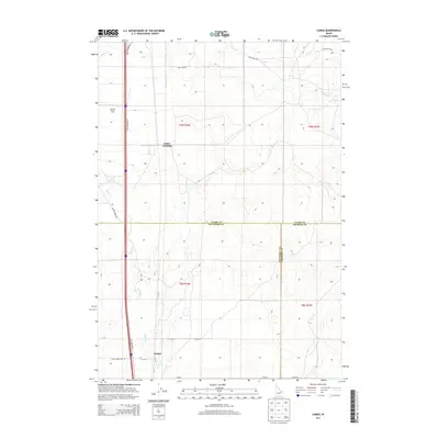
2013 Map of Camas
USGS Topo · Published 2013About this map
Jones Crossing and the settlement of Camas anchor this high-desert landscape where Jefferson, Clark, and Fremont counties converge. The geography is defined by the drainage of Beaver Cr and Camas Cr, which wind through the open terrain of Dutch Flat. This modern 2013 survey illustrates a rural infrastructure centered on agriculture and livestock, evidenced by corridors like Lamb Shed Rd and the historical transit route of Old Highway 91. The map reveals the precise section lines and township boundaries of T9N and T8N, showing how early homesteading patterns have evolved into the large-scale land management seen today. Researchers can trace the intersection of water and roadway access that dictated the location of early rural hubs in this corner of Idaho.
Find a feature on this map
22 named features on this map. Tap any name to fly to it.
Don’t see what you’re looking for? This feature index may not catch every label — zoom into the map to look around manually.
Map Details
Editions of this 2013 Camas Map
This is the sole edition of this map. No revisions or reprints were ever made.
Other maps of this area

1955 · Dubois
USGS Topo · 1:250,000

1955 · Idaho Falls
USGS Topo · 1:250,000

1958 · Dubois
USGS Topo · 1:250,000

1958 · Idaho Falls
USGS Topo · 1:250,000

1964 · Dubois NW
USGS Topo · 1:24,000

1964 · Lone Butte
USGS Topo · 1:24,000

1964 · Dubois NE
USGS Topo · 1:24,000
1964 · Hamer
USGS Topo · 1:24,000

1964 · Camas
USGS Topo · 1:24,000

1964 · Rays Lake
USGS Topo · 1:24,000