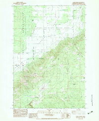
1983 Map of Camas Prairie
USGS Topo · Published 1983About this map
Camas Prairie and the surrounding high-country landscape define this transition between the wetland basin and the rising slopes of the Yakima Indian Reservation. This 1983 provisional survey highlights the intersection of public conservation and cultural history, centered on the Conboy Lake National Wildlife Refuge. The map captures several sites of particular importance to local researchers and genealogists, including the Whitcomb Cabin and the Dunkard Graveyard. The rugged topography transitions from the lowlands of Panakanic toward the elevated reaches of The Plateau. Water is a defining element across this terrain, with dozens of named sources such as Willard Spring and Log Corral Spring feeding into Rattlesnake Creek and Bird Creek. The inclusion of the Liberty Bond location suggests the area's legacy of early twentieth-century settlement and resource extraction within Klickitat County.
Find a feature on this map
29 named features on this map. Tap any name to fly to it.
Don’t see what you’re looking for? This feature index may not catch every label — zoom into the map to look around manually.
Map Details
Editions of this 1983 Camas Prairie Map
This is the sole edition of this map. No revisions or reprints were ever made.
Other maps of this area

1904 · Mount Adams
USGS Topo · 1:125,000

1907 · Mount Adams
USGS Topo · 1:125,000

1934 · The Dalles
USGS Topo · 1:125,000

1950 · Yakima
USGS Topo · 1:250,000

1953 · The Dalles
USGS Topo · 1:250,000

1956 · The Dalles
USGS Topo · 1:250,000

1957 · The Dalles
USGS Topo · 1:250,000

1957 · Klickitat
USGS Topo · 1:62,500

1957 · Husum
USGS Topo · 1:62,500

1958 · Yakima
USGS Topo · 1:250,000