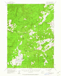
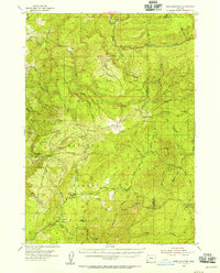
1955 Map of Camas Valley
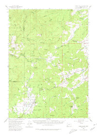
USGS Topo · Published 1962About this map
The Middle Fork Coquille River and East Fork Coquille River converge in a region defined by high ridges and settled valley floors during the mid-1950s. The settlement of Camas Valley serves as a local hub, situated near the Patterson Cemetery and Martindale Cemetery, indicating deep-rooted family histories in this part of Douglas County. Further east, the community of Tenmile and the winding Olalla Creek corridor show a landscape of small schools, such as the Upper Olalla School, and local millponds, reflecting the timber-driven economy of the era. High points like Camas Mtn and Mt Gurney overlook a network of primitive routes including the Wagon Road and Burnt Ridge Road. This survey provides a look at the transition from high-elevation forest management, represented by Camas Mtn State Park, to the agricultural and residential pockets found along Flournoy Valley and Sugar Pine Creek.
Find a feature on this map
57 named features on this map. Tap any name to fly to it.
Don’t see what you’re looking for? This feature index may not catch every label — zoom into the map to look around manually.
Map Details
Editions of this 1955 Camas Valley Map
3 editions found
Other maps of this area

1897 · Roseburg
USGS Topo · 1:125,000

1900 · Roseburg
USGS Topo · 1:125,000

1904 · Riddle
USGS Topo · 1:125,000

1928 · Sitkum
USGS Topo · 1:125,000
1946 · Dutchman Butte
USGS Topo · 1:62,500
1948 · Dutchman Butte
USGS Topo · 1:62,500
1954 · Bone Mountain
USGS Topo · 1:62,500
1954 · Sutherlin
USGS Topo · 1:62,500
1954 · Canyonville
USGS Topo · 1:62,500
1955 · Camas Valley
USGS Topo · 1:62,500