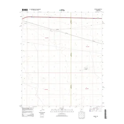
2013 Map of Cambray
USGS Topo · Published 2013About this map
Cambray sits at the northern edge of this high-desert landscape in the Chihuahuan Desert, serving as a focal point along the transport corridor shared by Frontage Rd and local access routes. The settlement is positioned near the junction of major surveyed townships, including t24s r5w and t24s r4w. To the southeast, the terrain is defined by the prominent volcanic rise of Providence Cone, which stands as a clear landmark in an otherwise open expanse. The map details the administrative boundary between Luna County and Doña Ana County, illustrating how this geopolitical line bisects the arid flats and utility corridors such as Pipeline Rd and Co Road B008.
Find a feature on this map
10 named features on this map. Tap any name to fly to it.
Don’t see what you’re looking for? This feature index may not catch every label — zoom into the map to look around manually.
Map Details
Editions of this 2013 Cambray Map
This is the sole edition of this map. No revisions or reprints were ever made.
Other maps of this area

1941 · Aden
USGS Topo · 1:62,500

1943 · Aden
USGS Topo · 1:62,500

1943 · Corralitos Ranch
USGS Topo · 1:62,500

1955 · Las Cruces
USGS Topo · 1:250,000

1958 · Las Cruces
USGS Topo · 1:250,000

1972 · Myndus
USGS Topo · 1:24,000

1972 · Cambray
USGS Topo · 1:24,000
1972 · X-7 Ranch
USGS Topo · 1:24,000

1972 · Lazy E Ranch
USGS Topo · 1:24,000
1972 · Akela
USGS Topo · 1:24,000