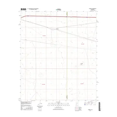
2017 Map of Cambray
USGS Topo · Published 2017About this map
Cambray occupies a central position in this high-desert landscape, situated along a transportation corridor that crosses the county line between Luna County and Doña Ana County. The topography is defined by the stark rise of Providence Cone in the southeast, a distinctive volcanic landform that breaks the surrounding flats. Surveyed in the 21st century, the map reveals the persistence of the Public Land Survey System, with township and range lines like t24s r4w and t25s r5w providing the geometric framework for the modern landscape. Infrastructure is sparse but significant, characterized by the long transit of Pipeline Rd and the major highway and rail lines that parallel the northern edge of the quadrangle, serving as vital links through this arid region of Southern New Mexico.
Find a feature on this map
8 named features on this map. Tap any name to fly to it.
Don’t see what you’re looking for? This feature index may not catch every label — zoom into the map to look around manually.
Map Details
Editions of this 2017 Cambray Map
This is the sole edition of this map. No revisions or reprints were ever made.
Other maps of this area

1941 · Aden
USGS Topo · 1:62,500

1943 · Aden
USGS Topo · 1:62,500

1943 · Corralitos Ranch
USGS Topo · 1:62,500

1955 · Las Cruces
USGS Topo · 1:250,000

1958 · Las Cruces
USGS Topo · 1:250,000

1972 · Myndus
USGS Topo · 1:24,000

1972 · Cambray
USGS Topo · 1:24,000
1972 · X-7 Ranch
USGS Topo · 1:24,000

1972 · Lazy E Ranch
USGS Topo · 1:24,000
1972 · Akela
USGS Topo · 1:24,000