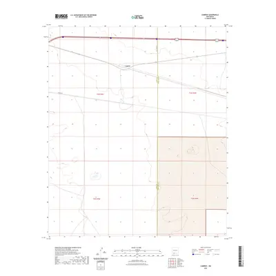
2023 Map of Cambray
USGS Topo · Published 2023About this map
The small settlement of Cambray sits along the northern edge of this high-desert landscape in southwestern New Mexico. This 2023 edition documents a region defined by transit and utility infrastructure, with Route 549 and Interstate 70 180 cutting through the northern sections. Modern development is further evidenced by labels for Cell Tower Rd and Pipeline Rd, which trace the path of essential services across the arid terrain. The map also delineates the jurisdictional boundary between Luna Co and Doña Ana Co, a point of interest for local researchers tracking regional land divisions. The area is marked by a clear grid of sections, including t24s r5w and t25s r4w, which define the ranching and public land survey system that still governs this part of the Chihuahuan Desert.
Find a feature on this map
10 named features on this map. Tap any name to fly to it.
Don’t see what you’re looking for? This feature index may not catch every label — zoom into the map to look around manually.
Map Details
Editions of this 2023 Cambray Map
This is the sole edition of this map. No revisions or reprints were ever made.
Other maps of this area

1941 · Aden
USGS Topo · 1:62,500

1943 · Aden
USGS Topo · 1:62,500

1943 · Corralitos Ranch
USGS Topo · 1:62,500

1955 · Las Cruces
USGS Topo · 1:250,000

1958 · Las Cruces
USGS Topo · 1:250,000

1972 · Myndus
USGS Topo · 1:24,000

1972 · Cambray
USGS Topo · 1:24,000
1972 · X-7 Ranch
USGS Topo · 1:24,000

1972 · Lazy E Ranch
USGS Topo · 1:24,000
1972 · Akela
USGS Topo · 1:24,000