
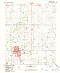
2010 Map of Cambridge
USGS Topo · Published 2010About this map
Pleasant Ridge Cemetery sits in the northeast corner of this landscape, a lone landmark in the rural expanse of Kiowa County. The terrain is defined by the winding paths of Elk Creek, which meanders north to south across the central and eastern sections, and Tepee Creek in the southwest. This area is structured by an extensive grid of section-line roads, such as E 1310 Rd and N 2160 Rd, reflecting the methodical agricultural subdivision of the Oklahoma plains. The presence of Iris St in the south suggests a cluster of local activity or a small crossroads node amidst the dominant pattern of farm roads and drainage basins. This map highlights the subtle hydrology of the region, where numerous small ponds and ephemeral water bodies are scattered along the tributaries of the main creek systems.
Find a feature on this map
18 named features on this map. Tap any name to fly to it.
Don’t see what you’re looking for? This feature index may not catch every label — zoom into the map to look around manually.
Map Details
Editions of this 2010 Cambridge Map
This is the sole edition of this map. No revisions or reprints were ever made.
Other maps of this area

1955 · Lawton
USGS Topo · 1:250,000

1955 · Clinton
USGS Topo · 1:250,000

1957 · Clinton
USGS Topo · 1:250,000

1961 · Hobart
USGS Topo · 1:62,500

1961 · Retrop
USGS Topo · 1:62,500

1963 · Babbs
USGS Topo · 1:24,000

1964 · Lone Wolf
USGS Topo · 1:24,000

1971 · Lake Altus
USGS Topo · 1:24,000

1984 · Sentinel
USGS Topo · 1:24,000
1984 · Hobart
USGS Topo · 1:24,000