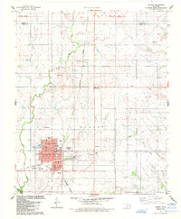
1984 Map of Hobart
USGS Topo · Published 1985About this map
The Rainey Mountain Indian Treaty Boundary cuts across the northern landscape of this Oklahoma survey, marking a significant historical line in the territory. To the south, the city of Hobart serves as the regional hub, displaying a dense residential grid supported by several educational institutions, including Willard Sch, Middle Sch, and the Hobart 8TH ST Field Sch. The town's infrastructure at this time is further defined by the Burlington Northern tracks and the Fairground located on the eastern edge of the settlement.
Find a feature on this map
24 named features on this map. Tap any name to fly to it.
Don’t see what you’re looking for? This feature index may not catch every label — zoom into the map to look around manually.
Map Details
Editions of this 1984 Hobart Map
This is the sole edition of this map. No revisions or reprints were ever made.
Other maps of this area

1949 · Cooperton
USGS Topo · 1:62,500

1955 · Lawton
USGS Topo · 1:250,000

1955 · Clinton
USGS Topo · 1:250,000

1956 · Rainy Mountain Creek
USGS Topo · 1:24,000

1956 · Cooperton
USGS Topo · 1:62,500

1957 · Clinton
USGS Topo · 1:250,000

1961 · Gotebo
USGS Topo · 1:62,500

1961 · Hobart
USGS Topo · 1:62,500

1963 · Babbs
USGS Topo · 1:24,000

1964 · Lone Wolf
USGS Topo · 1:24,000