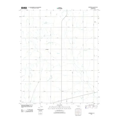
2012 Map of Cambridge
USGS Topo · Published 2012About this map
Cambridge serves as the focal point of this agricultural landscape in Kiowa County, where the grid of rural section lines creates a rigid geometry across the Oklahoma plains. The drainage patterns of Elk Cr and Tepee Cr carve subtle variations into the terrain, contrasting with the precise alignment of roads like e1340 RD and n2130 RD. To the northeast, the Pleasant Ridge Cem stands as a significant landmark for genealogical research, anchoring the history of the local farming community. This map illustrates the intersection of modern infrastructure and traditional land divisions, showing how small-scale watercourses continue to influence the placement of homesteads and transit routes in a region defined by its expansive horizontal reach.
Find a feature on this map
22 named features on this map. Tap any name to fly to it.
Don’t see what you’re looking for? This feature index may not catch every label — zoom into the map to look around manually.
Map Details
Editions of this 2012 Cambridge Map
This is the sole edition of this map. No revisions or reprints were ever made.
Other maps of this area

1955 · Lawton
USGS Topo · 1:250,000

1955 · Clinton
USGS Topo · 1:250,000

1957 · Clinton
USGS Topo · 1:250,000

1961 · Hobart
USGS Topo · 1:62,500

1961 · Retrop
USGS Topo · 1:62,500

1963 · Babbs
USGS Topo · 1:24,000

1964 · Lone Wolf
USGS Topo · 1:24,000

1971 · Lake Altus
USGS Topo · 1:24,000

1984 · Sentinel
USGS Topo · 1:24,000
1984 · Hobart
USGS Topo · 1:24,000