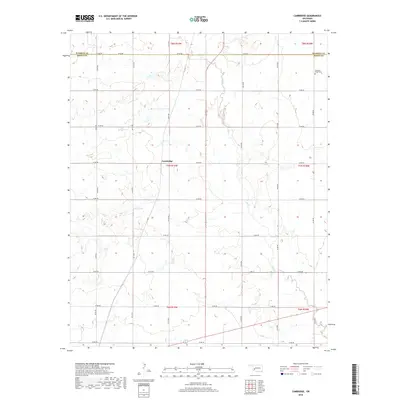
2018 Map of Cambridge
USGS Topo · Published 2018About this map
Cambridge sits at the heart of this Western Oklahoma survey, marking a distinct intersection of township boundaries and rural section roads. The landscape is defined by the winding course of Elk Cr as it meanders southward through the prairie, joined by tributaries like Tepee Cr. This area highlights the rigid Public Land Survey System, with a dense grid of numbered roads such as N2120 Rd and E1340 Rd providing access to the agricultural plots that dominate the terrain. Near the northern boundary, the Pleasant Ridge Cem serves as a significant local landmark for genealogists, situated just south of the Co Line Rd that separates Kiowa and Washita counties. The map captures a moment of modern rural infrastructure, where utility and history meet in the preservation of old cemetery sites and the maintenance of a sprawling section-line road network.
Find a feature on this map
28 named features on this map. Tap any name to fly to it.
Don’t see what you’re looking for? This feature index may not catch every label — zoom into the map to look around manually.
Map Details
Editions of this 2018 Cambridge Map
This is the sole edition of this map. No revisions or reprints were ever made.
Other maps of this area

1955 · Lawton
USGS Topo · 1:250,000

1955 · Clinton
USGS Topo · 1:250,000

1957 · Clinton
USGS Topo · 1:250,000

1961 · Hobart
USGS Topo · 1:62,500

1961 · Retrop
USGS Topo · 1:62,500

1963 · Babbs
USGS Topo · 1:24,000

1964 · Lone Wolf
USGS Topo · 1:24,000

1971 · Lake Altus
USGS Topo · 1:24,000

1984 · Sentinel
USGS Topo · 1:24,000
1984 · Hobart
USGS Topo · 1:24,000