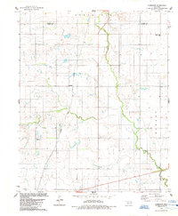
1984 Map of Cambridge
USGS Topo · Published 1985About this map
Cambridge sits at a crossroads of rail and water in this mid-1980s look at the Oklahoma plains. The Atchison Topeka and Santa Fe railroad cuts a vertical path through the terrain, passing through the Dill district and providing a industrial backbone to the agricultural landscape. The serpentine course of Elk Creek winds through the eastern half of the map, carving through the South Elk and Hobart areas. This survey reflects the region's enduring rural structure, where family and community landmarks like Pleasant Ridge Cem remain central to the geography. The map also documents modern infrastructure, including a prominent substation and various benchmark locations that define the elevation and survey grid across the Washita and Kiowa county line.
Find a feature on this map
10 named features on this map. Tap any name to fly to it.
Don’t see what you’re looking for? This feature index may not catch every label — zoom into the map to look around manually.
Map Details
Editions of this 1984 Cambridge Map
This is the sole edition of this map. No revisions or reprints were ever made.
Other maps of this area

1955 · Lawton
USGS Topo · 1:250,000

1955 · Clinton
USGS Topo · 1:250,000

1957 · Clinton
USGS Topo · 1:250,000

1961 · Hobart
USGS Topo · 1:62,500

1961 · Retrop
USGS Topo · 1:62,500

1963 · Babbs
USGS Topo · 1:24,000

1964 · Lone Wolf
USGS Topo · 1:24,000

1971 · Lake Altus
USGS Topo · 1:24,000

1984 · Sentinel
USGS Topo · 1:24,000
1984 · Hobart
USGS Topo · 1:24,000