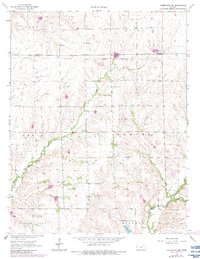
1964 Map of Cambridge NW
USGS Topo · Published 1983About this map
The Old Indian Treaty Boundary carves a straight horizontal line across this Kansas landscape, marking a historical division just north of the Butler and Cowley County line. The terrain is defined by the winding paths of Timber Creek and Grouse Creek, which feed into the smaller Gardners Branch at the southern edge of the quadrangle. Early 20th-century development is visible through the Old RR Grade that passes near Wingate, a small settlement node on the plains. This 1960s survey, updated in the early 1980s, reveals the intersection of agriculture and industry with the presence of the Grouse Creek Oil Field. Community life is anchored by local landmarks such as the Timber Creek Ch, Timber Creek Cem, and Mt Vernon Cem, providing valuable points of reference for genealogists and local historians tracking rural Kansas roots.
Find a feature on this map
18 named features on this map. Tap any name to fly to it.
Don’t see what you’re looking for? This feature index may not catch every label — zoom into the map to look around manually.
Map Details
Editions of this 1964 Cambridge NW Map
2 editions found
Other maps of this area

1888 · Eldorado
USGS Topo · 1:125,000

1889 · Burden
USGS Topo · 1:125,000

1955 · Wichita
USGS Topo · 1:250,000

1958 · Wichita
USGS Topo · 1:250,000

1962 · Grand Summit
USGS Topo · 1:24,000

1962 · Cambridge
USGS Topo · 1:24,000

1964 · Augusta SE
USGS Topo · 1:24,000

1964 · Latham
USGS Topo · 1:24,000

1964 · Cambridge NW
USGS Topo · 1:24,000
1964 · Cambridge NE
USGS Topo · 1:24,000