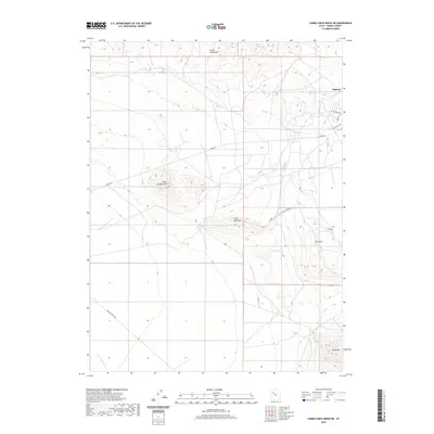
2020 Map of Camels Back Ridge NE
USGS Topo · Published 2020About this map
The high desert landscape of Tooele County unfolds across this survey, centered on the military and geographic installations near Dugway. The terrain is defined by isolated peaks and ridges rising from the basin floor, including Little Granite Mtn and the southern reaches of the Cedar Mountains. The map reveals a specialized infrastructure of roads and avenues, such as W Knight Ave, Doolittle Ave, and Carr Cir, which intersect with long-distance desert routes like Stark Rd and Simpson Springs Rd. Water is scarce in this arid environment, represented only by the intermittent course of Government Cr. To the southeast, Little Davis Mtn, Flat Hills, and Davis Mtn provide significant vertical relief, while numbered tracks like tc0386 suggest a network of administrative or specialized access paths through the scrubland.
Find a feature on this map
17 named features on this map. Tap any name to fly to it.
Don’t see what you’re looking for? This feature index may not catch every label — zoom into the map to look around manually.
Map Details
Editions of this 2020 Camels Back Ridge NE Map
This is the sole edition of this map. No revisions or reprints were ever made.
Other maps of this area

1885 · Tooele Valley
USGS Topo · 1:250,000

1953 · Tooele
USGS Topo · 1:250,000

1954 · Camels Back Ridge NW
USGS Topo · 1:24,000

1955 · Tabbys Peak SE
USGS Topo · 1:24,000

1955 · Camels Back Ridge SW
USGS Topo · 1:24,000

1955 · Simpson Springs
USGS Topo · 1:24,000

1955 · Indian Peaks
USGS Topo · 1:24,000

1955 · Camels Back Ridge NE
USGS Topo · 1:24,000

1955 · Davis Knolls
USGS Topo · 1:24,000

1955 · Deseret Peak
USGS Topo · 1:62,500