
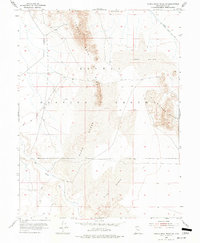
1955 Map of Camels Back Ridge SW
USGS Topo · Published 1956About this map
Dugway Proving Ground dominates this 1955 survey of the Utah desert, revealing a landscape defined by shifting sands and ancient geological markers. The terrain is anchored by the prominent Camels Back Ridge and the Simpson Buttes to the east, while the southern portion of the quadrangle is bisected by the Old River Bed. This dry channel indicates a prehistoric watercourse that once flowed through what is now an arid expanse of Sand Dunes. For historians and researchers, the map documents early infrastructure within the military reservation, including a network of Jeep Trails and specific industrial sites such as Quarries located along the western slopes of the ridge. The map captures the area during a period of intense military testing and desert navigation in the mid-1950s.
Find a feature on this map
8 named features on this map. Tap any name to fly to it.
Don’t see what you’re looking for? This feature index may not catch every label — zoom into the map to look around manually.
Map Details
Editions of this 1955 Camels Back Ridge SW Map
2 editions found
Other maps of this area

1885 · Sevier Desert
USGS Topo · 1:250,000

1885 · Tooele Valley
USGS Topo · 1:250,000

1908 · Fish Springs
USGS Topo · 1:250,000

1910 · Fish Springs
USGS Topo · 1:250,000

1953 · Dugway Range NE
USGS Topo · 1:24,000

1953 · Dugway Range
USGS Topo · 1:62,500

1953 · Tooele
USGS Topo · 1:250,000

1953 · Delta
USGS Topo · 1:250,000

1954 · Dugway Proving Ground SE
USGS Topo · 1:24,000

1954 · Dugway Proving Ground NE
USGS Topo · 1:24,000