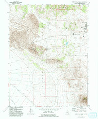
1993 Map of Camels Back Ridge NE
USGS Topo · Published 1993About this map
Dugway Proving Ground (Restricted Area) dominates the landscape, illustrating the intersection of natural isolation and specialized human activity in the late 20th century. The settlement at English Village serves as a primary hub within this secure zone, supported by facilities like the Rodeo Grounds, Rifle Range, and a designated Experimental Area. The topography is defined by the sharp transition between the Cedar Mountains and a massive expanse of Sand Dunes to the west.
Find a feature on this map
18 named features on this map. Tap any name to fly to it.
Don’t see what you’re looking for? This feature index may not catch every label — zoom into the map to look around manually.
Map Details
Editions of this 1993 Camels Back Ridge NE Map
This is the sole edition of this map. No revisions or reprints were ever made.
Other maps of this area

1885 · Tooele Valley
USGS Topo · 1:250,000

1953 · Tooele
USGS Topo · 1:250,000

1954 · Camels Back Ridge NW
USGS Topo · 1:24,000

1955 · Tabbys Peak SE
USGS Topo · 1:24,000

1955 · Camels Back Ridge SW
USGS Topo · 1:24,000

1955 · Simpson Springs
USGS Topo · 1:24,000

1955 · Indian Peaks
USGS Topo · 1:24,000

1955 · Camels Back Ridge NE
USGS Topo · 1:24,000

1955 · Davis Knolls
USGS Topo · 1:24,000

1955 · Deseret Peak
USGS Topo · 1:62,500