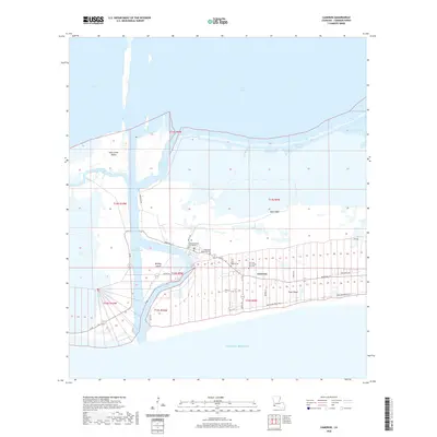
2020 Map of Cameron
USGS Topo · Published 2020About this map
Cameron serves as the focal point of this coastal survey, where the Cameron Parish Courthouse stands near the intersection of La 27 82 and Marshall St. The landscape is defined by its precarious relationship with the water, characterized by elevated strips of land like Front Ridge and Back Ridge that offer reprieve from the surrounding wetlands. To the west, the Calcasieu Ship Channel and Calcasieu Pass facilitate heavy maritime traffic between Calcasieu Lake and the Gulf of Mexico, isolating Monkey Island and Saint Johns Island from the mainland. Local heritage is preserved in several community sites, including Wakefield Memorial Cem, Kelly-Rogers Cem, and Our Lady Star of the Sea Cem. The intricate network of smaller waterways, such as Tripod Bayou and the Lake Shore Canal, illustrates the complex drainage and transportation patterns of this marshy terrain.
Find a feature on this map
40 named features on this map. Tap any name to fly to it.
Don’t see what you’re looking for? This feature index may not catch every label — zoom into the map to look around manually.
Map Details
Editions of this 2020 Cameron Map
This is the sole edition of this map. No revisions or reprints were ever made.
Other maps of this area

1934 · Cameron
USGS Topo · 1:24,000

1934 · Holly Beach
USGS Topo · 1:24,000

1934 · Sweet Lake
USGS Topo · 1:24,000

1934 · Browns Lake
USGS Topo · 1:24,000

1934 · Grand Bayou
USGS Topo · 1:24,000

1935 · Cameron
USGS Topo · 1:31,680

1935 · Sweet Lake
USGS Topo · 1:31,680

1935 · Hackberry
USGS Topo · 1:31,680

1935 · Holly Beach
USGS Topo · 1:31,680

1935 · Grand Bayou
USGS Topo · 1:31,680