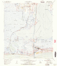
1955 Map of Cameron
USGS Topo · Published 1956About this map
Calcasieu Lake dominates this coastal landscape, where the shifting boundaries of marsh and water define the region's character in the mid-1950s. The settlement of Cameron sits at the junction of Calcasieu Pass and the Gulf of Mexico, serving as a critical maritime hub with its U S Coast Guard Station and prominent Ship Channel. To the north, Hackberry stands as a primary inland community, featuring Hackberry High Sch and St Peter Ch amidst a network of industrial infrastructure, including the Rygade Canal and various oil and gas wells.
Find a feature on this map
51 named features on this map. Tap any name to fly to it.
Don’t see what you’re looking for? This feature index may not catch every label — zoom into the map to look around manually.
Map Details
Editions of this 1955 Cameron Map
3 editions found
Other maps of this area

1932 · Moss Lake
USGS Topo · 1:31,680

1932 · Orange
USGS Topo · 1:62,500

1932 · Lake Charles SW
USGS Topo · 1:31,680

1934 · Cameron
USGS Topo · 1:24,000

1934 · Holly Beach
USGS Topo · 1:24,000

1934 · Peveto Beach
USGS Topo · 1:24,000

1934 · Sweet Lake
USGS Topo · 1:24,000

1934 · Browns Lake
USGS Topo · 1:24,000

1934 · Grand Bayou
USGS Topo · 1:24,000

1934 · Five Lakes
USGS Topo · 1:24,000