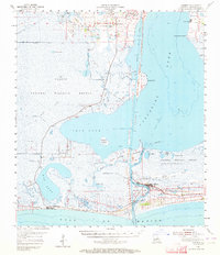
1955 Map of Cameron
USGS Topo · Published 1964About this map
Sabine National Wildlife Refuge dominates this coastal landscape, protecting a complex network of wetlands and ridges between Calcasieu Lake and the Gulf of Mexico. In the mid-1950s, the area's economy is clearly defined by the Calcasieu Ship Channel and the burgeoning petroleum industry, evidenced by the Gas Field and Mud Lake Gas Field. The settlement of Hackberry serves as a local hub near the northern edge, containing St Peter Ch and the Hackberry High Sch.
Find a feature on this map
47 named features on this map. Tap any name to fly to it.
Don’t see what you’re looking for? This feature index may not catch every label — zoom into the map to look around manually.
Map Details
Editions of this 1955 Cameron Map
3 editions found
Other maps of this area

1932 · Moss Lake
USGS Topo · 1:31,680

1932 · Orange
USGS Topo · 1:62,500

1932 · Lake Charles SW
USGS Topo · 1:31,680

1934 · Cameron
USGS Topo · 1:24,000

1934 · Holly Beach
USGS Topo · 1:24,000

1934 · Peveto Beach
USGS Topo · 1:24,000

1934 · Sweet Lake
USGS Topo · 1:24,000

1934 · Browns Lake
USGS Topo · 1:24,000

1934 · Grand Bayou
USGS Topo · 1:24,000

1934 · Five Lakes
USGS Topo · 1:24,000