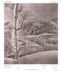
1975 Map of Cameron
USGS Topo · Published 1976About this map
Cameron stands at the strategic intersection of coastal marshes and the shipping channel during the mid-1970s. This orthophotoquad captures the physical reality of the Louisiana coastline, where the settlement is bound by the waters of Calcasieu Lake to the north and the Gulf of Mexico to the south. The imagery highlights the industrial and maritime character of the town, particularly along the banks of Calcasieu Pass, which serves as a vital conduit for vessel traffic. Unlike traditional topographic maps, this aerial perspective reveals the intricate patterns of marshland drainage and the precise layout of local infrastructure, including the piers and roadways that supported the region's fishing and oil industries at the time of the flight in March 1975.
Find a feature on this map
4 named features on this map. Tap any name to fly to it.
Don’t see what you’re looking for? This feature index may not catch every label — zoom into the map to look around manually.
Map Details
Editions of this 1975 Cameron Map
This is the sole edition of this map. No revisions or reprints were ever made.
Other maps of this area

1934 · Cameron
USGS Topo · 1:24,000

1934 · Holly Beach
USGS Topo · 1:24,000

1934 · Sweet Lake
USGS Topo · 1:24,000

1934 · Browns Lake
USGS Topo · 1:24,000

1934 · Grand Bayou
USGS Topo · 1:24,000

1935 · Cameron
USGS Topo · 1:31,680

1935 · Sweet Lake
USGS Topo · 1:31,680

1935 · Hackberry
USGS Topo · 1:31,680

1935 · Holly Beach
USGS Topo · 1:31,680

1935 · Grand Bayou
USGS Topo · 1:31,680