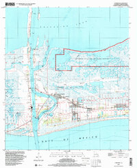
1998 Map of Cameron
USGS Topo · Published 2000About this map
Cameron sits at the critical junction where the Calcasieu Pass meets the Gulf of Mexico, serving as a vital coastal hub for both the maritime and energy industries at the end of the 20th century. The landscape is dominated by the industrial footprint of the Cameron Oil and Gas Field and a significant refinery, illustrating the region's economic reliance on offshore and coastal extraction. To the north and east, the transition from industrial zones to protected wetlands is marked by the sprawling Sabine National Wildlife Refuge and the marshes surrounding Tripod Bayou. Genealogists will find notable burial sites including Wakefield Mem Cem and Kelly-Rogers Cem near the town center. The presence of the Calcasieu Ship Channel and various heliports underscores the intensive transportation network required to support the local economy, while landmarks like Monkey Island and Back Ridge define the local topography.
Find a feature on this map
29 named features on this map. Tap any name to fly to it.
Don’t see what you’re looking for? This feature index may not catch every label — zoom into the map to look around manually.
Map Details
Editions of this 1998 Cameron Map
This is the sole edition of this map. No revisions or reprints were ever made.
Other maps of this area

1934 · Cameron
USGS Topo · 1:24,000

1934 · Holly Beach
USGS Topo · 1:24,000

1934 · Sweet Lake
USGS Topo · 1:24,000

1934 · Browns Lake
USGS Topo · 1:24,000

1934 · Grand Bayou
USGS Topo · 1:24,000

1935 · Cameron
USGS Topo · 1:31,680

1935 · Sweet Lake
USGS Topo · 1:31,680

1935 · Hackberry
USGS Topo · 1:31,680

1935 · Holly Beach
USGS Topo · 1:31,680

1935 · Grand Bayou
USGS Topo · 1:31,680