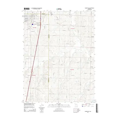
2014 Map of Cameron East
USGS Topo · Published 2014About this map
Cameron is the principal hub on this 2014 survey, where the grid of city streets like W 8th St and E Evergreen St gives way to the agricultural expanses of the Clinton and Caldwell County line. The landscape is dotted with small family and community burial grounds, including the Evergreen Cemetery, Packard Cemetery, and the distant Paxton Cemetery to the southeast. These sites, along with the Cameron Memorial Gardens, provide valuable touchpoints for genealogists tracing regional family history.
Find a feature on this map
95 named features on this map. Tap any name to fly to it.
Don’t see what you’re looking for? This feature index may not catch every label — zoom into the map to look around manually.
Map Details
Editions of this 2014 Cameron East Map
This is the sole edition of this map. No revisions or reprints were ever made.
Other maps of this area

1923 · Maysville
USGS Topo · 1:62,500

1924 · Polo
USGS Topo · 1:62,500

1924 · Winston
USGS Topo · 1:62,500

1925 · Plattsburg
USGS Topo · 1:62,500

1925 · Maysville
USGS Topo · 1:62,500

1950 · Kansas City
USGS Topo · 1:250,000

1954 · Kansas City
USGS Topo · 1:250,000

1956 · Kansas City
USGS Topo · 1:250,000

1960 · Kansas City
USGS Topo · 1:250,000
1983 · Fordham
USGS Topo · 1:24,000