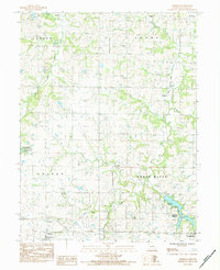
1983 Map of Fordham
USGS Topo · Published 1984About this map
The Grand River and its numerous tributaries, including Wheeler Creek and Bee Creek, define the rolling landscape of DeKalb County in the early 1980s. This survey captures a rural environment marked by early utility and transit corridors, such as a wooden pole transmission line and an old railroad grade that runs north through Fordham. The presence of the Pony Express State Wildlife Area and its associated Pony Express Lake highlights a shift toward conservation and public recreation alongside traditional agriculture. Several quarries dot the hills, indicating local mineral extraction in the townships of Camden, Adams, and Colfax. For genealogists, the map preserves the exact locations of family and community landmarks like Redman Cem and Mt Pleasant Cem, while the southern border shows the early growth of Osborn and Cameron near the Cameron Reservoirs.
Find a feature on this map
24 named features on this map. Tap any name to fly to it.
Don’t see what you’re looking for? This feature index may not catch every label — zoom into the map to look around manually.
Map Details
Editions of this 1983 Fordham Map
This is the sole edition of this map. No revisions or reprints were ever made.
Other maps of this area

1923 · Maysville
USGS Topo · 1:62,500

1924 · Polo
USGS Topo · 1:62,500

1924 · Winston
USGS Topo · 1:62,500

1925 · Plattsburg
USGS Topo · 1:62,500

1925 · Maysville
USGS Topo · 1:62,500

1950 · Kansas City
USGS Topo · 1:250,000

1954 · Kansas City
USGS Topo · 1:250,000

1956 · Kansas City
USGS Topo · 1:250,000

1960 · Kansas City
USGS Topo · 1:250,000
1983 · Maysville
USGS Topo · 1:24,000