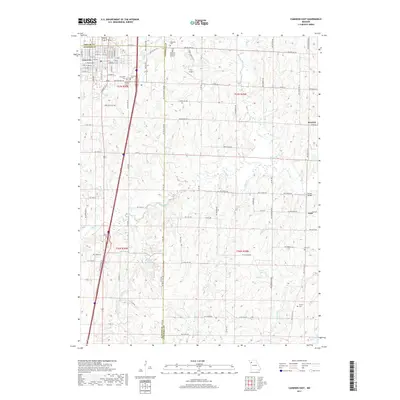
2017 Map of Cameron East
USGS Topo · Published 2017About this map
Cameron and its surrounding rural landscapes are detailed here, situated at the juncture of DeKalb, Clinton, and Caldwell counties. The residential layout of the eastern half of the city includes distinct developments like Heritage Hills Dr, while the outlying areas are defined by a network of creeks such as Brushy Cr, Shoal Cr, and Deer Cr. The area is notably dense with burial sites, including Evergreen Cem, Graceland Cem, and the family-named McDaniel Cem, which provide significant anchor points for local genealogical research. In the countryside, small water bodies like Lake Allaman and Sloan Lake punctuate the agricultural grid, while landmarks like the CCC Airport and Stoner Bridge indicate historical infrastructure in settlements like Barwick and Kerr.
Find a feature on this map
72 named features on this map. Tap any name to fly to it.
Don’t see what you’re looking for? This feature index may not catch every label — zoom into the map to look around manually.
Map Details
Editions of this 2017 Cameron East Map
This is the sole edition of this map. No revisions or reprints were ever made.
Other maps of this area

1923 · Maysville
USGS Topo · 1:62,500

1924 · Polo
USGS Topo · 1:62,500

1924 · Winston
USGS Topo · 1:62,500

1925 · Plattsburg
USGS Topo · 1:62,500

1925 · Maysville
USGS Topo · 1:62,500

1950 · Kansas City
USGS Topo · 1:250,000

1954 · Kansas City
USGS Topo · 1:250,000

1956 · Kansas City
USGS Topo · 1:250,000

1960 · Kansas City
USGS Topo · 1:250,000
1983 · Fordham
USGS Topo · 1:24,000