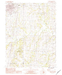
1984 Map of Cameron East
USGS Topo · Published 1984About this map
Shoal Creek and its many tributaries, including Brushy Creek and Plum Creek, carve a detailed drainage pattern across this north-central Missouri landscape. The eastern outskirts of Cameron appear in the northwest, where the Burlington Northern railroad corridor meets a cluster of local landmarks like Parkview Sch and Graceland Cem. The map reveals a high density of rural burial grounds, such as Mc Daniel Cem and Paxton Cem, which serve as critical markers for genealogists tracing early families in the borderlands of Clinton and Caldwell counties.
Find a feature on this map
29 named features on this map. Tap any name to fly to it.
Don’t see what you’re looking for? This feature index may not catch every label — zoom into the map to look around manually.
Map Details
Editions of this 1984 Cameron East Map
This is the sole edition of this map. No revisions or reprints were ever made.
Other maps of this area

1923 · Maysville
USGS Topo · 1:62,500

1924 · Polo
USGS Topo · 1:62,500

1924 · Winston
USGS Topo · 1:62,500

1925 · Plattsburg
USGS Topo · 1:62,500

1925 · Maysville
USGS Topo · 1:62,500

1950 · Kansas City
USGS Topo · 1:250,000

1954 · Kansas City
USGS Topo · 1:250,000

1956 · Kansas City
USGS Topo · 1:250,000

1960 · Kansas City
USGS Topo · 1:250,000
1983 · Fordham
USGS Topo · 1:24,000