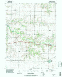
1996 Map of Cameron
USGS Topo · Published 1997About this map
Cameron and the surrounding townships of Floyd and Coldbrook characterize this portion of Western Illinois in the late 1990s. The landscape is defined by the deep incisions of Cedar Creek and its tributaries, including Talbot Creek and Henderson Creek, which carve through the otherwise rectilinear grid of agricultural land. While the eastern edge of Monmouth shows modern development like the Monmouth Park and nearby golf courses, much of the quadrangle preserves its rural 19th-century DNA. Family names are anchored to the land through numerous burial grounds such as Terpening Cem, Mosher Cem, and Patterson Cem. These sites, along with rural landmarks like the Warren Sch, provide critical touchstones for genealogists and local historians tracing the distribution of early settlements like Gerlaw and Coldbrook.
Find a feature on this map
26 named features on this map. Tap any name to fly to it.
Don’t see what you’re looking for? This feature index may not catch every label — zoom into the map to look around manually.
Map Details
Editions of this 1996 Cameron Map
This is the sole edition of this map. No revisions or reprints were ever made.
Other maps of this area

1921 · Monmouth
USGS Topo · 1:62,500

1923 · Monmouth
USGS Topo · 1:62,500

1923 · Alexis
USGS Topo · 1:62,500

1925 · Alexis
USGS Topo · 1:62,500

1925 · Galesburg
USGS Topo · 1:62,500

1927 · Galesburg
USGS Topo · 1:62,500

1947 · Woodhull
USGS Topo · 1:62,500

1958 · Burlington
USGS Topo · 1:250,000

1958 · Davenport
USGS Topo · 1:250,000

1961 · Burlington
USGS Topo · 1:250,000