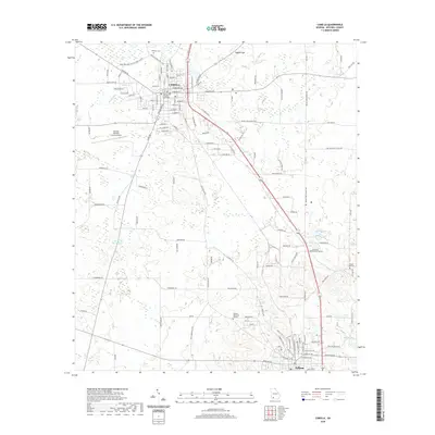
2020 Map of Camilla
USGS Topo · Published 2020About this map
Camilla, the county seat of Mitchell County, serves as the primary hub for this agricultural region, anchored by the centrally located Mitchell County Courthouse. The town's grid is dense with named streets, reflecting decades of development from E Broad St to S Boulevard St. To the south, Pelham marks the lower boundary of the quadrangle, connected to the north by a corridor of transportation and industry.
Find a feature on this map
121 named features on this map. Tap any name to fly to it.
Don’t see what you’re looking for? This feature index may not catch every label — zoom into the map to look around manually.
Map Details
Editions of this 2020 Camilla Map
This is the sole edition of this map. No revisions or reprints were ever made.
Other maps of this area

1953 · Dothan
USGS Topo · 1:250,000

1954 · Dothan
USGS Topo · 1:250,000

1955 · Dothan
USGS Topo · 1:250,000

1956 · Baconton
USGS Topo · 1:62,500

1956 · Newton
USGS Topo · 1:62,500

1971 · Meigs
USGS Topo · 1:24,000

1971 · Gee Pond
USGS Topo · 1:24,000

1971 · Camilla
USGS Topo · 1:24,000

1971 · Cotton
USGS Topo · 1:24,000
1971 · Pelham
USGS Topo · 1:24,000