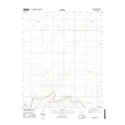
2017 Map of Cammak Camp
USGS Topo · Published 2017About this map
Cammak Camp sits in the northeast quadrant of this high-plains landscape in Quay County, where the terrain is defined by the sharp descent into the Canadian River valley. The river cuts a dramatic, winding path along the southern edge of the sheet, revealing the complex topography of the breaks that separate the flat mesas from the water's edge. To the northwest, Sager Draw marks the drainage patterns that characterize this arid ranching country. The map illustrates the sparse settlement and vast open spaces typical of the Llano Estacado region, centered on the intersections of several townships including t14n r35e and t15n r36e. This 2017 survey captures the enduring rural character of the area, where land use is dictated by the deeply carved river corridor and the seasonal draws that feed it.
Find a feature on this map
9 named features on this map. Tap any name to fly to it.
Don’t see what you’re looking for? This feature index may not catch every label — zoom into the map to look around manually.
Map Details
Editions of this 2017 Cammak Camp Map
This is the sole edition of this map. No revisions or reprints were ever made.
Other maps of this area

1954 · Tucumcari
USGS Topo · 1:250,000

1958 · Tucumcari
USGS Topo · 1:250,000

1962 · Logan
USGS Topo · 1:62,500

1966 · Lockney
USGS Topo · 1:24,000

1968 · Blue Hole
USGS Topo · 1:24,000

1968 · Cammak Camp
USGS Topo · 1:24,000

1968 · Sanchez Springs
USGS Topo · 1:24,000
1968 · Martin Draw
USGS Topo · 1:24,000

1971 · Obar
USGS Topo · 1:24,000

1971 · Nara Visa
USGS Topo · 1:24,000