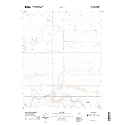
2023 Map of Cammak Camp
USGS Topo · Published 2023About this map
The Canadian River cuts through the southern reaches of this Quay County landscape, defining the primary hydrological character of the region. This area is shaped by a high-plains geography where seasonal watercourses like Sager Draw feed into the river system. The map reveals a strictly regulated grid of section lines across townships T13N through T15N, typical of the western ranching and farming territories. Modern infrastructure is represented by a sparse network of rural routes, including Quay Road J and Quay Rd 84, which connect these open lands. The presence of the Q R 80.4 designation highlights the systematic organization of local transport within the modern New Mexico cattle country.
Find a feature on this map
12 named features on this map. Tap any name to fly to it.
Don’t see what you’re looking for? This feature index may not catch every label — zoom into the map to look around manually.
Map Details
Editions of this 2023 Cammak Camp Map
This is the sole edition of this map. No revisions or reprints were ever made.
Other maps of this area

1954 · Tucumcari
USGS Topo · 1:250,000

1958 · Tucumcari
USGS Topo · 1:250,000

1962 · Logan
USGS Topo · 1:62,500

1966 · Lockney
USGS Topo · 1:24,000

1968 · Blue Hole
USGS Topo · 1:24,000

1968 · Cammak Camp
USGS Topo · 1:24,000

1968 · Sanchez Springs
USGS Topo · 1:24,000
1968 · Martin Draw
USGS Topo · 1:24,000

1971 · Obar
USGS Topo · 1:24,000

1971 · Nara Visa
USGS Topo · 1:24,000