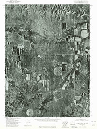
1973 Map of Camp Clarke 3 SE
USGS Topo · Published 1975About this map
Redington and the surrounding rangeland of the Nebraska Panhandle are captured here during the early 1970s. This orthophotomosaic, created from high-altitude aerial photography, provides a clear view of the agricultural transition in Morrill County, where traditional rectangular fields meet the circular patterns of center-pivot irrigation. The water system is anchored by the meandering path of Pumpkin Creek and its tributary Lawrence Fork, which carve through the high plains. In the northern reaches, the terrain breaks into more complex formations near Sand Point, contrasting with the orderly grid of local roads and farmsteads. This document preserves the physical layout of the ranching and farming landscape at a time when modern irrigation technology was beginning to fundamentally reshape the visual character of the Western plains.
Find a feature on this map
4 named features on this map. Tap any name to fly to it.
Don’t see what you’re looking for? This feature index may not catch every label — zoom into the map to look around manually.
Map Details
Editions of this 1973 Camp Clarke 3 SE Map
This is the sole edition of this map. No revisions or reprints were ever made.
Other maps of this area

1898 · Camp Clarke
USGS Topo · 1:125,000

1954 · Scottsbluff
USGS Topo · 1:250,000

1958 · Scottsbluff
USGS Topo · 1:250,000

1965 · Bridgeport NW
USGS Topo · 1:24,000

1965 · South Bayard
USGS Topo · 1:24,000

1965 · McGrew
USGS Topo · 1:24,000

1972 · Horsehead Ranch
USGS Topo · 1:24,000

1973 · Bridgeport SW
USGS Topo · 1:24,000

1973 · Potter 2 NW
USGS Topo · 1:24,000
1973 · Potter 2 NE
USGS Topo · 1:24,000