
1973 Map of Potter 2 NW
USGS Topo · Published 1975About this map
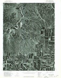
Lawrence Fork meanders across the center of this 1973 orthophotoquad, revealing the complex drainage patterns of this high plains landscape in Banner County. The aerial perspective, derived from imagery captured by the U.S. Geological Survey in May of that year, highlights the contrast between the deep incisions of Rocky Hollow and the surrounding tablelands. Unlike a traditional topographic line map, this orthophotomosaic provides a literal view of land use, where dark, rectilinear patterns indicate cultivated fields of winter wheat or fallow strips sharply defined against the lighter, broken terrain of the valley breaks. The scarcity of named landmarks underscores the remote character of this ranching and farming region, where the natural watercourses and geological depressions remain the primary orienting features for local families and researchers.
Find a feature on this map
2 named features on this map. Tap any name to fly to it.
Don’t see what you’re looking for? This feature index may not catch every label — zoom into the map to look around manually.
Map Details
Editions of this 1973 Potter 2 NW Map
This is the sole edition of this map. No revisions or reprints were ever made.
Other maps of this area

1898 · Scotts Bluff
USGS Topo · 1:125,000

1898 · Camp Clarke
USGS Topo · 1:125,000

1954 · Scottsbluff
USGS Topo · 1:250,000

1958 · Scottsbluff
USGS Topo · 1:250,000

1973 · Potter 2 SW
USGS Topo · 1:24,000

1973 · Scotts Bluff 4 SE
USGS Topo · 1:24,000

1973 · Kimball 1 SE
USGS Topo · 1:24,000

1973 · Kimball 1 NE
USGS Topo · 1:24,000

1973 · Potter 2 SE
USGS Topo · 1:24,000
1973 · Potter 2 NE
USGS Topo · 1:24,000