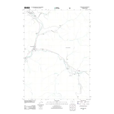
2012 Map of Camp Davis
USGS Topo · Published 2012About this map
Hoback Junction serves as the central waypoint where the Snake River meets the Hoback River in this Teton County landscape. The mapping of the early twenty-first century reveals a terrain defined by steep canyons and vital watercourses, where the transition from the high-elevation Camp Creek Saddle leads down into fertile river valleys. Significant local landmarks such as Camp Davis and the Broken Arrow Ranch are situated along the river bends, connected by a network of rural routes like Bryan Flat Rd and Spoiled Horse Rd. Geologic interest is found at Stinking Springs near the eastern edge of the quadrangle, while numerous drainages including Willow Cr and Horse Cr carve through the surrounding canyon walls, illustrating the complex hydrology that has shaped the human and natural development of this mountain region.
Find a feature on this map
31 named features on this map. Tap any name to fly to it.
Don’t see what you’re looking for? This feature index may not catch every label — zoom into the map to look around manually.
Map Details
Editions of this 2012 Camp Davis Map
This is the sole edition of this map. No revisions or reprints were ever made.
Other maps of this area

1931 · Jackson
USGS Topo · 1:125,000

1935 · Jackson
USGS Topo · 1:125,000

1955 · Driggs
USGS Topo · 1:250,000

1958 · Driggs
USGS Topo · 1:250,000

1962 · Driggs
USGS Topo · 1:250,000

1963 · Munger Mountain
USGS Topo · 1:24,000

1963 · Jackson
USGS Topo · 1:24,000

1965 · Camp Davis
USGS Topo · 1:24,000
1965 · Turquoise Lake
USGS Topo · 1:24,000
1965 · Cache Creek
USGS Topo · 1:24,000