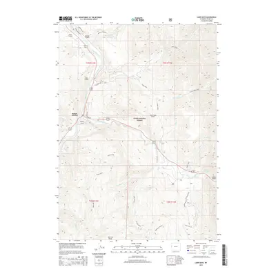
2015 Map of Camp Davis
USGS Topo · Published 2015About this map
Hoback Junction serves as the focal point of this terrain where the Snake River meets the Hoback River. The landscape is defined by its dramatic drainage networks and steep canyons, including Hoback Canyon, Coles Canyon, and Dells Canyon. Notable transportation corridors like the Old Yellowstone Rd and Swinging Bridge provide access into the heart of the Teton National Forest. In the southeast, Camp Davis sits near the confluence of Willow Cr and the Hoback River, serving as a landmark for those traveling toward the Wyoming Range. The presence of the Wyoming Range National Recreation Trail and named points like Stinking Springs highlight the area's significance for backcountry movement and natural water features during this period of the mid-2010s.
Find a feature on this map
40 named features on this map. Tap any name to fly to it.
Don’t see what you’re looking for? This feature index may not catch every label — zoom into the map to look around manually.
Map Details
Editions of this 2015 Camp Davis Map
This is the sole edition of this map. No revisions or reprints were ever made.
Other maps of this area

1931 · Jackson
USGS Topo · 1:125,000

1935 · Jackson
USGS Topo · 1:125,000

1955 · Driggs
USGS Topo · 1:250,000

1958 · Driggs
USGS Topo · 1:250,000

1962 · Driggs
USGS Topo · 1:250,000

1963 · Munger Mountain
USGS Topo · 1:24,000

1963 · Jackson
USGS Topo · 1:24,000

1965 · Camp Davis
USGS Topo · 1:24,000
1965 · Turquoise Lake
USGS Topo · 1:24,000
1965 · Cache Creek
USGS Topo · 1:24,000