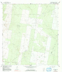
1965 Map of Camp Garcia
USGS Topo · Published 1991About this map
The industrial energy landscape of South Texas is on full display in this mid-1960s study of the area near the Starr Co Hidalgo Co line. Dominated by extensive petroleum development, the terrain is marked by a high density of Gas Wells, Oil Wells, and specialized infrastructure including a Compressor Sta and several Pumping Stas. The map reveals the organized extraction efforts within the Rincon Oil Field, Davenport Oil Field, Braulia Oil Field, Yturria Oil Field, and Borosa Oil Field. Away from the derricks, the map identifies local landholdings and small outposts such as Camp Garcia and the Samano Ranch. This survey provides researchers a clear view of the mid-century oil and gas boom as it shaped the rural borderlands, showing the complex network of pipelines and service roads that connected these isolated fields to the larger regional economy.
Find a feature on this map
17 named features on this map. Tap any name to fly to it.
Don’t see what you’re looking for? This feature index may not catch every label — zoom into the map to look around manually.
Map Details
Editions of this 1965 Camp Garcia Map
3 editions found
Other maps of this area

1938 · Sal Colorada
USGS Topo · 1:62,500

1939 · La Reforma
USGS Topo · 1:62,500

1940 · Monte Christo
USGS Topo · 1:62,500

1949 · Mc Allen
USGS Topo · 1:250,000

1954 · McAllen
USGS Topo · 1:250,000

1956 · Garcias
USGS Topo · 1:62,500

1957 · Mc Allen
USGS Topo · 1:250,000

1962 · McAllen
USGS Topo · 1:250,000

1963 · Citrus City
USGS Topo · 1:24,000
1963 · McCook
USGS Topo · 1:24,000