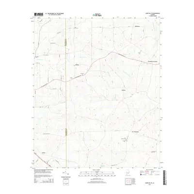
2014 Map of Camp Hill SE
USGS Topo · Published 2014About this map
The Tallapoosa and Chambers county line bisects this portion of rural Alabama, where agricultural land is shaped by the drainage of North Fork Sandy Creek and Little Chatahospee Creek. Several rural communities and crossroads define the landscape, including Kendall Crossroads, Culebra, and Blackman. The map reveals a high density of local heritage sites, specifically small family and community burial grounds such as the Dean Shirley Cemetery in the north and the Smith Willoughby Cemetery near New Harmony. These scattered sites, alongside the Stephens Mill Pond to the south, indicate a long-standing pattern of dispersed homesteads and small-scale industry centered on the area's creeks and branches. Modern infrastructure like the Veterans Memorial Parkway now cuts through these older settlement patterns, connecting Judson with the surrounding countryside.
Find a feature on this map
74 named features on this map. Tap any name to fly to it.
Don’t see what you’re looking for? This feature index may not catch every label — zoom into the map to look around manually.
Map Details
Editions of this 2014 Camp Hill SE Map
This is the sole edition of this map. No revisions or reprints were ever made.
Other maps of this area

1906 · Dadeville
USGS Topo · 1:125,000

1907 · Opelika
USGS Topo · 1:125,000

1909 · Opelika
USGS Topo · 1:125,000

1955 · Phenix City
USGS Topo · 1:250,000

1957 · Phenix City
USGS Topo · 1:250,000

1958 · Phenix City
USGS Topo · 1:250,000

1971 · Waverly
USGS Topo · 1:24,000
1971 · Moorefield
USGS Topo · 1:24,000
1971 · Lafayette
USGS Topo · 1:24,000
1971 · Opelika West
USGS Topo · 1:24,000