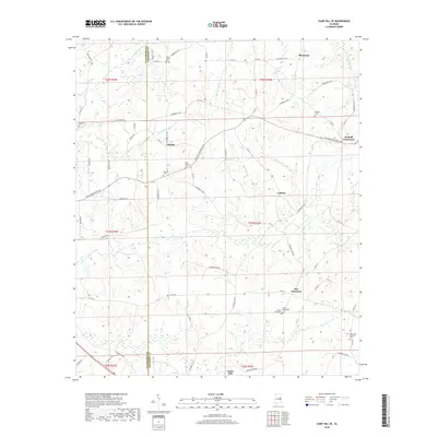
2018 Map of Camp Hill SE
USGS Topo · Published 2018About this map
Tallapoosa and Chambers County lands meet in this rural landscape, where established family burial grounds and small settlements reflect a deeply rooted agricultural community. Small hamlets like Kendall Crossroads and Judson are linked by a network of county roads, such as Veterans Memorial Pkwy and Carr Rd. The terrain is defined by its many drainages, including the N Fork Sandy Cr and Little Chattachospee Cr, which shaped the placement of early homesteads and industries like Jones Mill. Genealogists will find a high concentration of historic burial sites throughout the quadrangle, ranging from the New Canaan Cem to the Smith-Willoughby Cem and Mount Olive Cem near New Harmony. These landmarks, alongside the Peace and Goodwill Cem in the southeast, provide a clear record of the area's local history.
Find a feature on this map
76 named features on this map. Tap any name to fly to it.
Don’t see what you’re looking for? This feature index may not catch every label — zoom into the map to look around manually.
Map Details
Editions of this 2018 Camp Hill SE Map
This is the sole edition of this map. No revisions or reprints were ever made.
Other maps of this area

1906 · Dadeville
USGS Topo · 1:125,000

1907 · Opelika
USGS Topo · 1:125,000

1909 · Opelika
USGS Topo · 1:125,000

1955 · Phenix City
USGS Topo · 1:250,000

1957 · Phenix City
USGS Topo · 1:250,000

1958 · Phenix City
USGS Topo · 1:250,000

1971 · Waverly
USGS Topo · 1:24,000
1971 · Moorefield
USGS Topo · 1:24,000
1971 · Lafayette
USGS Topo · 1:24,000
1971 · Opelika West
USGS Topo · 1:24,000