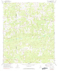
1981 Map of Camp Hill SE
USGS Topo · Published 1981About this map
Tallapoosa and Chambers counties meet amidst a landscape defined by small rural settlements and a dense network of country churches in the early 1970s. The southern edge of the map is anchored by the Central of Georgia railroad, which parallels the winding course of Sandy Creek. Local life centers around longstanding community points like Kendall Crossroads and the Plainview Sch, while numerous faith centers such as Mt Sinai Ch, Mt Lebanon Ch, and Peace and Goodwill Ch dot the rolling terrain. The intricate drainage of the Little Chatahospee Creek and various branches like Emfinger Branch and Gin Branch suggest a territory shaped by its creeks and small-scale agriculture. This survey provides a clear view of the area's social geography before modern development altered the rural character of these Alabama borderlands.
Find a feature on this map
29 named features on this map. Tap any name to fly to it.
Don’t see what you’re looking for? This feature index may not catch every label — zoom into the map to look around manually.
Map Details
Editions of this 1981 Camp Hill SE Map
This is the sole edition of this map. No revisions or reprints were ever made.
Other maps of this area

1906 · Dadeville
USGS Topo · 1:125,000

1907 · Opelika
USGS Topo · 1:125,000

1909 · Opelika
USGS Topo · 1:125,000

1955 · Phenix City
USGS Topo · 1:250,000

1957 · Phenix City
USGS Topo · 1:250,000

1958 · Phenix City
USGS Topo · 1:250,000

1971 · Waverly
USGS Topo · 1:24,000
1971 · Moorefield
USGS Topo · 1:24,000
1971 · Lafayette
USGS Topo · 1:24,000
1971 · Opelika West
USGS Topo · 1:24,000