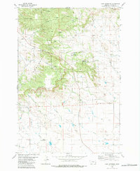
1980 Map of Camp Needmore
USGS Topo · Published 1980About this map
The Ekalaka Hills Unit Custer National Forest dominates the high ground of this Southeast Montana landscape, characterized by a complex network of springs and drainages. The area’s ranching and rural legacy is evident in the numerous water sources such as Marlin Spring, Twentytwo Spring, and Shady Spring, which supported livestock across the timbered ridges and open coulees. Down on the flats south of the Base Line, the Peabody School stands near the intersection of the Pershing Cutoff, marking a former focal point for the isolated homesteading community.
Find a feature on this map
22 named features on this map. Tap any name to fly to it.
Don’t see what you’re looking for? This feature index may not catch every label — zoom into the map to look around manually.
Map Details
Editions of this 1980 Camp Needmore Map
2 editions found
Other maps of this area

1954 · Ekalaka
USGS Topo · 1:250,000

1956 · Ekalaka
USGS Topo · 1:250,000

1958 · Ekalaka
USGS Topo · 1:250,000

1965 · Ekalaka
USGS Topo · 1:250,000

1979 · Dead Boy Divide
USGS Topo · 1:24,000

1979 · Ekalaka
USGS Topo · 1:24,000

1980 · Taylor Hills
USGS Topo · 1:24,000

1980 · Belltower
USGS Topo · 1:24,000

1980 · Camp Needmore
USGS Topo · 1:24,000

1980 · Dutchmans Hill
USGS Topo · 1:24,000