
1969 Map of Camp Springs
USGS Topo · Published 1972About this map
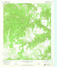
Camp Springs serves as the primary focal point of this West Texas landscape, straddling the county line between Scurry Co and Fisher Co. The area is defined by a series of drainage networks, including the meandering paths of Rough Creek, Gyp Draw, and Cottonwood Creek, which cut through the limestone and gypsum-rich terrain. The map captures a moment in the late 1960s where traditional ranching land use coexists with a growing petroleum infrastructure, evidenced by the numerous Oil Wells and a Pumping Sta located near the eastern boundary.
Find a feature on this map
21 named features on this map. Tap any name to fly to it.
Don’t see what you’re looking for? This feature index may not catch every label — zoom into the map to look around manually.
Map Details
Editions of this 1969 Camp Springs Map
This is the sole edition of this map. No revisions or reprints were ever made.
Other maps of this area

1926 · Snyder 1-a
USGS Topo · 1:48,000

1932 · Camp Springs
USGS Topo · 1:62,500

1952 · Hermleigh
USGS Topo · 1:24,000

1954 · Lloyd Mountain
USGS Topo · 1:24,000

1954 · Big Spring
USGS Topo · 1:250,000

1958 · Big Spring
USGS Topo · 1:250,000

1969 · Bull Creek
USGS Topo · 1:24,000

1969 · Inadale NW
USGS Topo · 1:24,000

1969 · Maverick Creek
USGS Topo · 1:24,000
1969 · Hudd
USGS Topo · 1:24,000