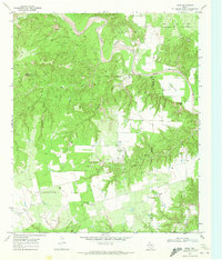
1969 Map of Hudd
USGS Topo · Published 1972About this map
The Double Mountain Fork Brazos River winds through the northern portion of this Scurry County landscape, carving a complex network of breaks and canyons including Red Canyon and the aptly named Impossible Canyon. By the late 1960s, the terrain south of the river transitions into the broad, agricultural expanse of Cottonwood Flat and Longhorn Valley. Small-scale settlement and ranching operations are anchored by the Criswell Ranch and the community of Hudd, which features a designated Landing Area. Genealogists and local historians will find the locations of Cottonwood Flat Cem and Riverdale Cem particularly useful for tracing early West Texas families. The map also documents the region's topographical landmarks, from the heights of Gobbler Mountain and Sugar Loaf to the drainage of Gyp Draw and Little Rough Creek.
Find a feature on this map
27 named features on this map. Tap any name to fly to it.
Don’t see what you’re looking for? This feature index may not catch every label — zoom into the map to look around manually.
Map Details
Editions of this 1969 Hudd Map
This is the sole edition of this map. No revisions or reprints were ever made.
Other maps of this area

1926 · Snyder 1-a
USGS Topo · 1:48,000

1932 · Camp Springs
USGS Topo · 1:62,500

1954 · Lloyd Mountain
USGS Topo · 1:24,000

1954 · Lubbock
USGS Topo · 1:250,000

1954 · Big Spring
USGS Topo · 1:250,000

1958 · Big Spring
USGS Topo · 1:250,000

1969 · Camp Springs
USGS Topo · 1:24,000
1969 · A B C Creek
USGS Topo · 1:24,000

1969 · Maverick Creek
USGS Topo · 1:24,000

1969 · Cooper Mountain
USGS Topo · 1:24,000