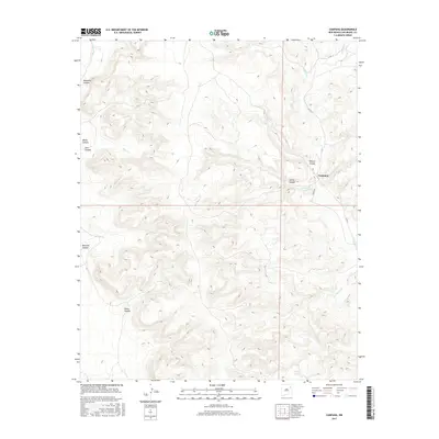
2017 Map of Campana
USGS Topo · Published 2017About this map
Campana anchors the eastern edge of this high-plains landscape in San Miguel County, where a network of ephemeral drainage systems carves deep into the plateau. The topography is defined by significant incisions such as Muertos Canyon and Polecat Canyon, which channel seasonal water toward Atarque Cr and Muertos Cr. This 2017 survey reveals a terrain primarily shaped by the erosive forces of the Canadian River watershed, evidenced by the numerous named canyons like China Canyon and Spring Canyon. Transportation in this sparsely populated area is limited to local routes such as Steves Rd and Co Rd J-1, which follow the natural contours of the mesas. The map provides a clear look at the ranching-oriented land use and the rugged relief that characterizes this section of northeastern New Mexico.
Find a feature on this map
15 named features on this map. Tap any name to fly to it.
Don’t see what you’re looking for? This feature index may not catch every label — zoom into the map to look around manually.
Map Details
Editions of this 2017 Campana Map
This is the sole edition of this map. No revisions or reprints were ever made.
Other maps of this area

1930 · Tucumcari
USGS Topo · 1:125,000

1954 · Santa Fe
USGS Topo · 1:250,000

1954 · Tucumcari
USGS Topo · 1:250,000

1958 · Santa Fe
USGS Topo · 1:250,000

1958 · Tucumcari
USGS Topo · 1:250,000

1968 · La Cinta Mesa
USGS Topo · 1:24,000

1968 · Carpenter Mesa NW
USGS Topo · 1:24,000
1968 · Medina Mesa
USGS Topo · 1:24,000

1969 · Salitre Canyon
USGS Topo · 1:24,000
1969 · Alamosa Canyon
USGS Topo · 1:24,000