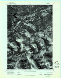
1977 Map of Campbell Brook
USGS Topo · Published 1983About this map
The Penobscot River winds through this timber-rich region of Somerset County, Maine, as it appeared in the late 1970s. This orthophotoquad provides a direct visual record of the forest canopy and logging infrastructure of the North Woods, highlighting the complex network of drainage basins that feed the state's most prominent river system. The terrain is defined by the high ground of No Mountain and the converging waters of Heald Stream, West Br Sandy Stream, and East Branch Sandy Stream. Small water bodies like Lacs and Oliva are visible in the northern reaches, while the South Branch and Campbell Brook carve deep valleys through the heavily wooded landscape. This 1977 imagery captures the area before modern harvesting patterns or road networks potentially altered the visual character of the watershed.
Find a feature on this map
10 named features on this map. Tap any name to fly to it.
Don’t see what you’re looking for? This feature index may not catch every label — zoom into the map to look around manually.
Map Details
Editions of this 1977 Campbell Brook Map
This is the sole edition of this map. No revisions or reprints were ever made.
Other maps of this area

1922 · Long Pond
USGS Topo · 1:62,500

1923 · Attean
USGS Topo · 1:62,500

1924 · Long Pond
USGS Topo · 1:62,500

1925 · Attean
USGS Topo · 1:62,500

1927 · Sandy Bay
USGS Topo · 1:48,000

1930 · Sandy Bay
USGS Topo · 1:62,500

1944 · Long Pond
USGS Topo · 1:62,500

1944 · Sandy Bay
USGS Topo · 1:62,500

1949 · Jackman
USGS Topo · 1:250,000

1950 · Attean
USGS Topo · 1:50,000