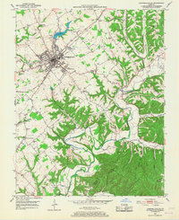
1986 Map of Campbellsville
USGS Topo · Published 1986This historical map portrays the area of Campbellsville in 1986, primarily covering Taylor County as well as portions of Casey County, Barren County, Larue County, Green County, Metcalfe County, Hardin County, Marion County, Hart County, Adair County, and Russell County. Featuring a scale of 1:100000, this map provides a highly detailed snapshot of the terrain, roads, buildings, counties, and historical landmarks in the Campbellsville region at the time. Published in 1986, it is one of 2 known editions of this map due to revisions or reprints.
Find a feature on this map
229 named features on this map. Tap any name to fly to it.
Don’t see what you’re looking for? This feature index may not catch every label — zoom into the map to look around manually.
Map Details
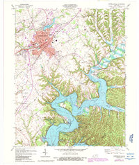
Editions of this 1986 Campbellsville Map
2 editions found
Historical Maps of Mount Gilead Through Time
3 maps found