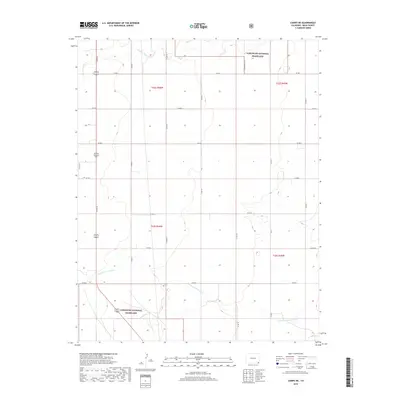
2019 Map of Campo NE
USGS Topo · Published 2019About this map
Comanche National Grassland dominates the landscape in this southeastern corner of Colorado, providing a look at the preserved shortgrass prairie system. The map documents a meticulously gridded network of rural transit, where roads like Co Rd 26 and Co Rd 32 trace section lines across the high plains. Hydrological features such as the N Fork Cimarron River and Sand Arroyo Cr cut across the landscape, illustrating the drainage patterns vital to the region's ranching and conservation history. This 2019 survey captures the area at a time when the balance between public grassland management and private agricultural sections, denoted by the township and range boundaries like t32s r46w, remains the defining characteristic of the Baca County terrain.
Find a feature on this map
23 named features on this map. Tap any name to fly to it.
Don’t see what you’re looking for? This feature index may not catch every label — zoom into the map to look around manually.
Map Details
Editions of this 2019 Campo NE Map
This is the sole edition of this map. No revisions or reprints were ever made.
Other maps of this area

1891 · Springfield
USGS Topo · 1:125,000

1892 · Vilas
USGS Topo · 1:125,000

1893 · Springfield
USGS Topo · 1:125,000

1955 · La Junta
USGS Topo · 1:250,000

1958 · La Junta
USGS Topo · 1:250,000

1968 · La Junta
USGS Topo · 1:250,000
1978 · Moore Draw SW
USGS Topo · 1:24,000

1978 · Springfield SW
USGS Topo · 1:24,000
1978 · Campo SW
USGS Topo · 1:24,000

1978 · Campo NE
USGS Topo · 1:24,000