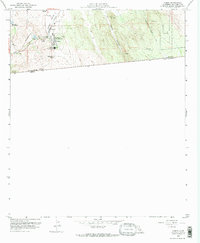
1959 Map of Campo
USGS Topo · Published 1973About this map
Campo sits directly at the international boundary between the United States and Mexico, where the San Diego and Arizona Eastern railroad winds through the arid terrain of Campo Valley. The map reveals a high-desert community defined by its ranching and educational hubs, including the Mtn Empire Union High Sch and the extensive Rancho Del Campo. To the east, the Campo Indian Reservation spans a landscape of sharp relief, marked by survey points like VABM 3690 Gill and the steep descent of Smith Canyon. This late 1950s documentation shows the area before significant modern border infrastructure changed the corridor, capturing a time when the Shockey Truck Trail and small ranching outposts like Castle Rock Ranch were the primary markers of human presence in this borderland.
Find a feature on this map
23 named features on this map. Tap any name to fly to it.
Don’t see what you’re looking for? This feature index may not catch every label — zoom into the map to look around manually.
Map Details
Editions of this 1959 Campo Map
4 editions found
Other maps of this area

1903 · Cuyamaca
USGS Topo · 1:125,000

1904 · Southern California Sheet No. 2
USGS Topo · 1:250,000

1931 · Carrizo
USGS Topo · 1:125,000

1939 · Campo
USGS Topo · 1:62,500

1942 · Potrero
USGS Topo · 1:48,000

1942 · Campo
USGS Topo · 1:62,500

1944 · Potrero
USGS Topo · 1:62,500

1950 · San Diego
USGS Topo · 1:250,000

1954 · San Diego
USGS Topo · 1:250,000

1955 · San Diego
USGS Topo · 1:250,000