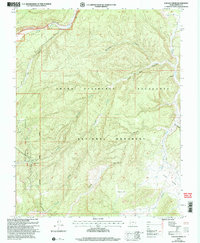
2002 Map of Canaan Creek
USGS Topo · Published 2005About this map
Upper Valley and the high drainage basins of the Grand Staircase - Escalante National Monument dominate this landscape, which was revised by the Forest Service just after the turn of the millennium. The terrain is defined by a dense network of seasonal drainages, including Canaan Creek, Willow Creek, and Alvey Wash, which carve through the high plateaus. The northern edge of the map shows the corridor of Highway 12, also designated as the All American Road, providing a key vantage point at the Overlook. Industrial footprints are visible through scattered Prospects and an Oil Well located near the boundary of the Dixie National Forest. Evidence of historical land use appears in the naming of localized features like Cherry Flat and the various springs, such as Horse Spring, which were vital markers in this arid environment.
Find a feature on this map
23 named features on this map. Tap any name to fly to it.
Don’t see what you’re looking for? This feature index may not catch every label — zoom into the map to look around manually.
Map Details
Editions of this 2002 Canaan Creek Map
This is the sole edition of this map. No revisions or reprints were ever made.
Other maps of this area

1886 · Escalante
USGS Topo · 1:250,000

1956 · Escalante
USGS Topo · 1:250,000

1960 · Escalante
USGS Topo · 1:250,000

1964 · Griffin Point
USGS Topo · 1:24,000

1964 · Dave Canyon
USGS Topo · 1:24,000

1964 · Canaan Creek
USGS Topo · 1:24,000

1964 · Canaan Peak
USGS Topo · 1:24,000

1964 · Death Ridge
USGS Topo · 1:24,000

1964 · Carcass Canyon
USGS Topo · 1:24,000
1964 · Wide Hollow Reservoir
USGS Topo · 1:24,000