
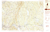
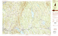
1984 Map of Canaan
USGS Topo · Published 1990About this map
Moose Mountain dominates the central topography of this mid-1980s survey, separating the valley of Goose Pond from the western settlements of Hanover Center and Etna. The landscape is defined by the historic corridor of the Boston and Maine RR, which follows the Mascoma River through West Canaan and Enfield. This survey captures the rural character of the Grafton County highlands before modern expansion, showing the proximity of the Mascoma Valley Regional High Sch to the waters of Mascoma Lake.
Find a feature on this map
75 named features on this map. Tap any name to fly to it.
Don’t see what you’re looking for? This feature index may not catch every label — zoom into the map to look around manually.
Map Details
Editions of this 1984 Canaan Map
3 editions found
Other maps of this area

1896 · Strafford
USGS Topo · 1:62,500

1906 · Hanover
USGS Topo · 1:62,500

1908 · Hanover
USGS Topo · 1:62,500

1927 · Cardigan
USGS Topo · 1:62,500

1927 · Mascoma
USGS Topo · 1:62,500

1928 · Rumney
USGS Topo · 1:62,500

1930 · Cardigan
USGS Topo · 1:62,500

1931 · Mt. Cube
USGS Topo · 1:62,500

1932 · Mascoma
USGS Topo · 1:62,500

1932 · Rumney
USGS Topo · 1:62,500